
Front of Town Hall
200 Main Street, Yarmouth, MAINE 04096
Monday - Friday: 8:30am - 4:30pm


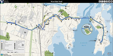
West Side Trail information


HELP US BRIDGE THE GAP
$35,000 is needed to replace a Failing Bridge and Trail
Dear Friends of the West Side Trail,
We’re starting 2026 off with an urgent request to protect one of Yarmouth’s treasured community assets: the West Side Trail. We are currently more than half way towards our goal, but we must close the gap- ASAP!
A rapidly failing stream bank has put a key section of the trail and bridge at risk of collapse and unless we act now, we may lose access to this beautiful corridor for an extended period of time.
HERE'S THE SITUATION
In 2023, our trail team noticed a crack forming down the center of the blue trail near the bridge just south of Gilman Road. What looked like a small issue has now become a serious threat. Over the last year, the streambank below the trail has eroded dramatically—carving out a 10-foot stretch of trail edge with a sudden 1—3-foot drop. The unstable soils are continuing to slump into the stream, and the bank is now compromised and may be too unstable to support the trail in a matter of 6 to 12 months.
THE ROAD AHEAD
Our engineering team reached a difficult but clear conclusion: this section of the streambank cannot be stabilized in a reliable, long-term way. The clay soils beneath the bank are simply too soft and too unstable. Continuing erosion could collapse the trail entirely and there is nowhere to relocate it as the other side of the trail is a steep embankment.
The only safe, lasting solution is to build a new bridge that spans over the unstable area and connects to solid ground on both sides.
This new bridge will:
-
Span 85 feet over the eroding bank
-
Be a safe 6 feet wide with railings
-
Use helical piles anchored into stable soils
-
Create a long-term, resilient crossing that protects the trail for decades to come
Because stabilizing the streambank would require lengthy and expensive state and federal permits—delaying construction more than a year—we must pursue the bridge solution now. A new bridge is straightforward to permit and offers a permanent long-term solution. Waiting risks losing this section of the blue trail altogether.
And timing is critical.
Our contractor has a narrow window of availability this fall. If we can fund the project immediately, construction can begin between now and January 1st before winter storms accelerate erosion and make the trail unsafe or impassable.
The total cost: $35,000.
This covers the helical piles, bridge structure, railings, site preparation, and the removal of two diseased trees that currently threaten both the project area and nearby power lines.
We are asking our trail users, neighbors, and community supporters to help us raise the full amount as quickly as possible so we can keep the West Side Trail open.
The West Side Trail is part of what makes Yarmouth such a great place to live. It's used daily by walkers, trail runners, mountain bikers, dog owners, families, and visitors. Together, we can protect it.
WILL YOU HELP US MEET THIS URGENT NEED?
Your gift today will directly support the construction of the new bridge and ensure that the West Side Trail remains open for everyone who loves it.
Thank you for caring about this special place.
Sincerely,
Dan Ostrye
West Side Trail Coordinator
A Trail Built by Community
The West Side Trail exists because of the dedication of volunteers and the generosity of people who believe in accessible, safe, and beautiful outdoor spaces. Your support will help ensure that this treasured communlty resource remains open and safe for years to come.
Thank you for being part of the West Side Trail community.

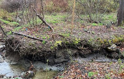


It all started in the spring of 2024 when we noticed a small crack in the trail on the far side of the bridge. Cracks like this usually indicate one thing: slope failure, which is a significant concern.
The stream erosion is located on the blue trail a few hundred yards from the upper Gilman Road trail crossing.
The stream is also undercutting the bank opposite the slump, indicating that stream flows have changed. It is impossible to predict when and how the stream channel will shift in the next few years.
But once we cleared the vegetation below the failure crack, we found that the bank had completely failed and slumped into the stream.
Over the summer we undertook short term stabilization of the existing bridge.
First by straightening the supports and re-leveling the bridge deck. Then, by installing pipe supports to carry the load until a permanent fix can be made.


Bridge alignment looking south. There is ls about a foot and a half of elevation difference between the two ends of the bridge (but it looks like there's a lot more than that when you’re standing there).